
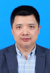
李振洪,博士、博士生导师,海外引进国家特聘专家,GEO中国专家工作组防灾减灾组组长;长安大学副校长,二级教授,测绘科学与技术学科带头人,黄土科学全国重点实验室副主任,陕西省基础学科(地球系统科学)研究中心副主任,陕西省科技创新团队负责人,陕西省“三秦学者”创新团队负责人,国家自然基金委川藏铁路重大项目首席科学家, 科技部国家重点研发项目首席科学家。长期从事影像大地测量与地质灾害及生态环境监测方面研究。
2010-2016: 英国自然科学研究基金会NERC地球物理和大地测量设施专委会委员
2011-2016: 国际大地测量学协会(IAG) SC4.4委员会主席:卫星成像系统和机载成像系统的应用
2016-2020: 欧洲遥感实验室协会(EARSeL)Radar特别兴趣组副主席
2016-2022: 国际摄影测量与遥感协会(ISPRS) 微波遥感工作组(WG III/2)副主席
2019-2022: 中国地球物理学会第十届理事会常务理事
2022-2025: 中国地球物理学会第十一届理事会常务理事
2023-2025: 中国测绘地理信息学会第十三届大地测量与导航专业委员会副主任委员
2023-2025: 中国遥感应用协会雷达遥感专业委员会副理事长
2020-2023: 陕西省测绘地理信息学会第十一届理事会副理事长
2020-2025: 中国灾害防御协会天空地多元信息与综合减灾技术专委会专家组副组长
2021-2025: 中国岩石力学与工程学会地质与岩土工程监测分会副理长
2021-2025: 中国地震学会地震灾害链专业委员会第一届副主任委员
2021-2025: 中国地理信息产业协会理论与方法工作委员会副主任委员
2021-至今: GEO中国专家工作组-防灾减灾组组长
2009-至今: 《Survey Review》编委
2016-至今: 《Advance in Space Research》副主编
2017-至今: 《Remote Sensing》责任副主编
2017-至今: 《Sensors》编委
2018-至今: 《Journal of Geodesy and Geoinformation Science》编委
2020-2022:《GeoEnvironmental Disasters》副主编
2021-至今: 《地球科学与环境学报》副主编
2022-2026:《武汉大学学报-信息科学版》编委
2022-2026:《Geodesy and Geodynamics》副主编
李振洪教授团队研究领域包括:
-卫星大地测量
-遥感(含SAR/InSAR、光学、高光谱)
-卫星大数据
-地壳运动、活动断层与地震
-地质灾害
-生态环境监测
-精准农业
本科大一:《测绘学概论》
本科大三:《数字高程模型》
本科大三:《科技论文写作》,《GNSS原理及应用》
本科大四:《合成孔径雷达干涉测量》
研究生课程:《对地观测技术及其应用》,《现代测绘技术创新与重大工程应用》
- 科技部国家重点研发计划“重大自然灾害监测预警与防范”重点专项,大范围自然灾害交通网信息全息感知与智能控制及安全诱导技术装备研发(项目编号:2020YFC1512000),2020.11-2024.10;首席。
- 国家自然科学基金委重大基金项目,川藏铁路重大灾害风险识别与预测(项目编号:41941019),2020.01-2023.12; 首席。
- 国家自然科学基金委重点国际合作研究项目,东非裂谷区地裂缝灾害机理与防控(项目编号:41920104010), 2020.01-2024.12;参与。
-陕西省科技创新团队:地质灾害监测预警和防控创新团队(项目编号:2021TD-51),2021-2023;项目负责人。
- 陕西省“三秦学者”创新团队:长安大学地学大数据与灾害防控创新团队(2022),2022-2026;项目负责人。
·UK-ChinaAgritech Challenge - REmote sensing and Decision support for Appletree Precision management, Production and globaL tracEability(RED-APPLE), BBSRC, United Kingdom, 2019.02-2022.02.
·Sentinelsof Wheat (ST/N006801/1), theSTFC-NSFC Newton Agri-Tech Joint Programme,2017-2019.
·PAFiC:Precision Agriculture for Family-farms in China (ST/N006801/1), theSTFC-NSFC Newton Agri-Tech Joint Programme,2016-2019.
·Community-basedearthquake disaster risk reduction in China (CEDRRiC):integrating local and scientific knowledge for planning andpreparedness (NE/N012151/1), theNERC-ESRC-NSFC Newton Fund - Increasing Resilience to NaturalHazards in Earthquake Prone Regions of China (IRNHiC),2016.01-2018.12.
·DRAGON-4:Earth observations for geohazard monitoring and riskassessment,EuropeanSpace Agency and the Ministry of Science and Technology (MOST),China,2016-2020.
·BuildingREsilience to Multi-source Flooding in South/Southeast Asia through aTechnology-informed Community-based approacH (REMATCH,NE/P015476/1), NERCGlobal Challenges Research Fund: Building Resilience,2016-2017.
·DRIER-China:Drought Resilience In Ecosystem services and Rural communities inChina (NE/P015484/1),NERCGlobal Challenges Research Fund: Building Resilience,2016-2017.
·Centrefor the Observation and Modelling of Earthquakes, Volcanoes andTectonics (COMET,come30001), NaturalEnvironment Research Council (NERC),United Kingdom, 2014-2019.
·Lookinginside the Continents from Space (LiCS):Insights into Earthquake Hazard and Crustal Deformation(NE/K010794/1), NaturalEnvironment Research Council (NERC) Large Grant,United Kingdom, 2014-2019.
·UrbanBig Data Research Centre, Economicand Social Research Council(ESRC) Large Grant,2014-2019.
·Exploringthe potential for precision nutrient management in China (PUMiC), theSTFC Newton Agri Tech Fund,2015-2016.
·RApID:Resilient Application of Intelligent Disaster management, theSTFC Newton Fund,2014-2015.
·ExemplarSmart Farming in Newcastle, theSTFC Newton Agri Tech Pathfinder programme,2014-2015.
·GroundBased Synthetic Aperture Radar (GB-SAR) (NERC Reference: CC049), NERCStrategic Environmental Science Capital Call,2014.
·RAEDistinguished Visiting Fellowship (to support Dr Maorong Ge fromGFZ): GNSS Seismology for responding to large earthquakes andmonitoring infrastructure stability, RoyalAcademy of Engineering,2014-2015.
·Assessingthe performances of Terrestrial Imaging Systems for TopographicMapping, NationalCentre for Earth Observation (NCEO),United Kingdom, 2013-2014.
·Integrationof GPS and InSAR for high precision deformation mapping, KeyLaboratory of Earth Fissures Geological Disaster, Ministry of Landand Resources (Geological Survey of Jiangsu Province),2013-2014.
·InSARfor the Earth’s surface deformation in the Fenwei Basin, ChinaGeological Survey - Chang’an University,2013-2015.
·Present-daycrustal deformation in Central Lhasa Plate and Characteristicsof the geodynamicprocess in preparation of strong earthquakes, ChinaEarthquake Administration (Institute of Crustal Dynamics),2013-2015.
·DRAGON-3:Monitoring crustal deformation and man-made infrastructure in Chinausing InSAR observations,EuropeanSpace Agency and the Ministry of Science and Technology (MOST),China,2012-2016.
·Usinghigh resolution topographic data to detect regions of high seismichazard from space, CarnegieTrust (Larger Grant),2012-2013.
·Polarimetricsynthetic aperture radar image processing for rapid assessment ofearthquake hazard damage, theRoyal Society of Edinburgh (RSE) - National Natural ScienceFoundation of China (NSFC) International Joint Project,2012-2014 (UK Leading PI).
·Landslideand Ground subsidence monitoring with advanced InSAR, ChinaGeological Survey - Chang’an University,2012-2014.
·SSSC-SFC:Feasibility of G-SAR toolbox for remote monitoring of infrastructurestability, ScottishFunding Council,2012-2013.
·GAS:Generic Atmosphere Solutions for radar measurements(NE/H001085/1),NaturalEnvironment Research Council (NERC),United Kingdom, 2009-2011 (PI).
·Multi-wavelengthPS InSAR techniques and their applications to land subsidence inEastern China, NationalNatural Science Foundation of China (NSFC),2011-2013 (Co-I; PI: Prof Guoxiang Liu, Southwest JiaotongUniversity, China).
·Useof InSAR to map surface cracks in Xi’an City, China. ChinaGeological Survey - Chang’an University,2009-2011.
·Centrefor the Observation and Modelling of Earthquakes, Volcanoes andTectonics (COMET+) , National Centre for Earth Observation (NCEO),Theme 6: Dynamic Earth and Geohazards. NaturalEnvironment Research Council (NERC),United Kingdom, 2008-2012 (Associated Investigator).
·DRAGON-2:Crustal deformation in China associated with the seismic cycle ofmajor faults or related to lakes loading on the lithosphere:Measurement by SAR Interferometry,EuropeanSpace Agency and the Ministry of Science and Technology (MOST),China,2008-2012.
·DRAGON-2:Monitoring ground surface displacement in the Three Gorges area,Dangxiong-Lasha and Jiangsu province area,EuropeanSpace Agency and the Ministry of Science and Technology (MOST),China,2008-2012.
·OSCAR:Online Services for Correcting Atmosphere in Radar, NASA,2009-2011 (Collaboratingwith Dr Paul von Allmen (PI) and Dr Eric Fielding at JPL).
·GeodeticImaging of Earth's Surface Deformation Using Integrated InSAR and GPSObservations, NASA,2008-2011 (Collaboratingwith Prof. William C. Hammond (PI), Prof. Geoffrey Blewitt, and Prof.Hans-Peter Plag at University of Nevada, Reno)
·Monitoractive faults using GPS/InSAR integrated techniques, China863 programme,2009-2010 (PI: Prof Caijun Xu, Wuhan University; ID: 2009AA12Z317).
·Usingspace geodesy techniques (i.e. GPS and InSAR) to monitor deformationover the Yellow River Delta, NationalNatural Science Foundation of China (NSFC),2006-2008 (PI: Prof Xinghua Zhou, First Institute of Oceanography,SOA, China; ID: 40576044).
论文统计
至2025年10月31日,发表专著1部,论文350余篇,其中SCI论文265篇,WoS高被引论文10篇。
李振洪,朱武,余琛,张勤,彭建兵(2025),影像大地测量与灾害动力学,科学出版社,242页。
2023夏坚白测绘事业创业与科技创新奖
2019王之卓青年科学家奖
2018The2018RAS Group Achievement Award in GeophysicsacknowledgesCOMET’s success in using satellite and ground-based observationsandgeophysical modelling to study earthquakes, volcanoes and tectonicsacross the globe.
2018The 2017Remote Sensing Best Guest Editor Awardto the Special Issueof Remote Sensing titled EarthObservations for Geohazards(Guest editors: ProfessorZhenhong Li and Professor Roberto Tomás Jover).
2016ESA and National Remote Sensing Centre of China Award of Excellencefor the DRAGON-3 project exploring Crustal Deformation andInfrastructure.
2005国家优秀自费留学生奖学金
2004Best Paper Presentation, the U.S. Institute of Navigation, USA.
2004Student Paper Prize, the U.S. Institute of Navigation, USA.
2019-至今:长安大学,教授
2014-2020:英国纽卡斯尔大学,教授
2011-2014:英国格拉斯哥大学,高级讲师(英制副教授)
2008-2011:英国格拉斯哥大学,讲师(英制助理教授)
2005-2008:英国伦敦大学学院,博士后
2020-2023:英国纽卡斯尔大学,访问教授
2015-2017:武汉大学地球空间信息技术协同创新中心,客座研究员
2012-2015:武汉大学,珞珈讲座教授
2010-2010:美国航空航天喷气动力实验室,访问科学家

 地址:西安市雁塔路126号地学科技大厦
 邮箱:sklls@chd.edu.cn
 电话:029-82339253
版权所有©长安大学 陕ICP备05001904号-1 陕公网安备 61011302000162号


